


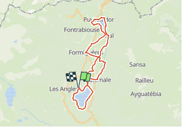
66 tour des lacs sur le plateau

ericf64
Gebruiker

Lengte
34 km

Max. hoogte
1569 m

Positief hoogteverschil
500 m
Km-Effort
40 km

Min. hoogte
1415 m

Negatief hoogteverschil
499 m
Boucle
Ja
Datum van aanmaak :
2023-07-17 07:20:22.783
Laatste wijziging :
2023-07-17 13:03:34.542
3h41
Moeilijkheid : Medium

Gratisgps-wandelapplicatie
 SityTrail
IGN / Geografische instituten
SityTrail Plus
De wereld gaat voor u open
Over ons
Tocht Mountainbike van 34 km beschikbaar op Occitanië, Pyrénées-Orientales, Les Angles. Deze tocht wordt voorgesteld door ericf64.
Plaatsbepaling
Land:
France
Regio :
Occitanië
Departement/Provincie :
Pyrénées-Orientales
Gemeente :
Les Angles
Locatie:
Unknown
Vertrek:(Dec)
Vertrek:(UTM)
425586 ; 4714395 (31T) N.
Opmerkingen